On the border of Lumajang and Malang Regencies, East Java.
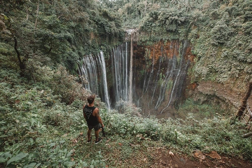
Lumajang–Malang Border · East Java
Tumpak Sewu Waterfall
Java's Niagara
Tumpak Sewu is a roughly 120 m semicircular multi-stream waterfall on the Lumajang–Malang border, formed by Mount Semeru's volcanic erosion and about 4 hours from Surabaya.
Elevation
~120 m drop
Location
Lumajang–Malang Border, East Java
Trailhead
Coban Sewu, Lumajang
From Surabaya
~4 hours
Best season
May–October
Physical demand
●●●●○
Destination overview
Tumpak Sewu, which translates to 'A Thousand Waterfalls' in Javanese, is one of Indonesia's most spectacular waterfall formations.
Located on the border between Lumajang and Malang regencies, this horseshoe-shaped waterfall cascades down a volcanic cliff face in hundreds of individual streams, creating a breathtaking natural curtain of water. The waterfall is fed by the Glidik River, which originates from the slopes of Mount Semeru, Java's highest and most active volcano. The panoramic viewpoint offers a stunning perspective with Semeru often visible in the background, especially during sunrise. The descent to the waterfall base involves navigating bamboo ladders, ropes, and rocky paths, making it an adventurous experience. Locals refer to Tumpak Sewu as 'Semeru's Breath,' representing the continuous flow of life from the volcano to the earth below.

What makes it remarkable
Indonesia's Most Photogenic Waterfall
Stunning horseshoe-shaped curtain of water with volcanic backdrop
Adventure Canyon Descent
Thrilling descent using ropes and ladders for an up-close experience
Mount Semeru Backdrop
Unique photography opportunity with Java's highest volcano in background
Unique Geological Formation
Volcanic erosion created this spectacular multi-stream waterfall
Goa Tetes Cave Connection
Explore the nearby cave system connected to the waterfall
Trek & terrain profile.
Difficulty
Moderate to Hard
Distance (full GPS route)0.7 km
Elev. gain (full route)+63 m
Max elevation568 m
Min elevation508 m
Loading 3D terrain…
Route data: AllTrails.com · 3D terrain via Mapbox
On the trail
Panoramic viewpoint accessible by short walk, then 45-60 minute descent to waterfall base using bamboo ladders, ropes, and rocky paths. Total distance: 1.5km round trip with 150m elevation change.
What to bring
trekking shoesgloveswaterproof bagdry clotheswater bottleheadlampponchotrekking poles
water flow
20-100 m³/s
humidity
75-95 %
visibility
1-5 km
rainfall alert
High risk
uv radiation
8-12 index
Police-led · private · verifiable
Why JVTO for Tumpak Sewu Waterfall.
Police-led
Founder Mr. Sam (Bripka Agung Sambuko) is an active Tourist Police (POLPAR) officer for Bondowoso. Route decisions answer to police protocol, not marketing metrics.
Authority100% private
Your own vehicle, driver, and crew — no shared jeeps, no strangers, no compromise on timing or pace.
PrivateAll-inclusive
Transport, entrance fees, accommodation, water, and T-shirt bundled. No surprise local payments on the day.
Written inclusionsVerifiable
NIB 1102230032918 checkable at OSS. POLPAR, BBKSDA, and HPWKI credentials listed. Every document publicly verifiable before you pay.
Proof libraryBook your trip
Tumpak Sewu Waterfall tour packages.
From Surabaya
Tumpak Sewu Waterfall from Surabaya
Midnight departure. Private vehicle, sunrise at the viewpoint, dedicated crew throughout.
View packagesFrom Bali
Tumpak Sewu Waterfall from Bali
Cross-island private package. Bali pickup, East Java circuit, return or drop at your next stop.
View packagesMulti-destination packages (3D2N to 6D5N) also available · See full list
Plan your day
Practical information.
Best season
May–October
Temperature
18-25°C in canyon, 22-30°C outside. Warm layers are recommended — wind chill at viewpoints is significant regardless of daytime temperatures lower down.
Physical requirements
Excellent physical condition required. Must be comfortable with heights, steep descents, and using ropes. Not recommended for people with mobility issues, fear of heights, or heart conditions.
Visitor tips
Recommended start 07:00–08:00, finish 11:00–13:00 before midday heat. Start early (by 6 AM) for best light and to avoid crowds, wear sturdy trekking shoes with grip, bring gloves for rope sections, use waterproof bags for electronics, carry water and snacks, respect the natural environment and guide instructions
Cultural context
Tumpak Sewu holds deep significance for the local communities who view the waterfall as 'Semeru's Breath' - the physical manifestation of the volcano's life force flowing to the earth. The continuous flow of water symbolizes renewal, humility, and the natural cycle of life. While less explicitly ritualized than other sites, the waterfall represents the power and generosity of nature in local cosmology. The name itself, 'A Thousand Waterfalls,' reflects the Javanese appreciation for nature's abundance and complexity.
Safety notes
- Guide mandatory for canyon descent - do not attempt alone
- Wear proper trekking shoes with excellent grip
- Use gloves for rope sections during descent
- Secure all electronics in waterproof bags
- Follow guide instructions carefully at all times
- Avoid visiting during or after heavy rain due to flash flood risk
- Helmets are provided by local Tumpak Sewu site management, not JVTO equipment
Risks and how JVTO handles them
terrain · Risk level: high
Steep and slippery descent with rope sections
What JVTO does about it: JVTO provides experienced guides and safety equipment. Descent is controlled and assisted.
weather · Risk level: high
Flash floods during rainfall
What JVTO does about it: JVTO monitors weather conditions and cancels visits during unsafe conditions. Emergency evacuation plans in place.
health · Risk level: medium
Physical exertion and potential for slips/falls
What JVTO does about it: Safety briefing and physical assessment. JVTO guides are trained in wilderness first aid.
Weather by season
Dry season (May-Oct): Best conditions with minimal rain, clear skies. Wet season (Nov-Apr): Heavy rainfall increases water flow and flash flood risk.
- Guide required
- Yes
- Rainfall
- High during wet season (300-600mm/month), Moderate during dry season (50-200mm/month)
- Local communities
- Java, Madura
- Trail start point (longitude, latitude)
- 112.91997, -8.23028
Included on all Tumpak Sewu Waterfall packages
- Private AC transport (fuel, tolls, parking)
- Dedicated driver and English-speaking guide
- BBKSDA national-park entrance fees
- Daily mineral water · JVTO T-shirt
- Accommodation & breakfast (overnight packages)
Not included
Flights · gratuities (guest discretion) · personal expenses · optional horse riding arranged on-site where available.
Permit & entry
JVTO includes all fees.
Visit Tumpak Sewu Waterfall with JVTO.
◆ Quick Answers
FAQ
Travel Guide
Packing & Fitness →Related Destinations